

Pithoragarh district is the easternmost hilly district in the state of Uttarakhand. The headquarter of the district is in Pithoragarh town which is located at a height of 1645 meters above sea level. The district lies along the eastern and southern part of the central Himalayas with the Indo-Tibetan watershed divide in the north and the Kali river.
It is naturally landscaped with high Himalayan mountains, snow-capped peaks, passes, valleys, and glaciers. There are numerous scenic spots like Chandak, Thal Kedar, Gangolihat, Patal Bhuvneshwar, Berinag, Didihat, Munsyari, Dharchula, and Jauljibi. Gangolihat is famous for its Kali temple. There is a Tea Garden of Chaukori which is located at Berinag in Pithoragarh. Munsyari is a famous hill station in Pithoragarh which is also known as the base camp for Kailas Mansarover Yatra.
Today we will explore everything about the Pithoragarh district. Here you will find compiled details on tourism, weather, education, distance, route map and places to visit in Pithoragarh.
Pithoragarh at a Glance
| Headquarter | Pithoragarh |
| Popular Places | Munsyari, Dharchula, |
| District Magistrate | Dr Vijay Kumar Jogdande (IAS) |
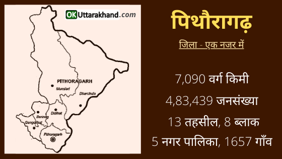
| Area | 7090 Sq Km |
| Tehsils | 13 |
| Vilages | 1657 |
| Population (2011) | 4,83,439 |
| Vehicle Registration | UK-05 |
| STD Code | 05964 |
| Pin Code | 262501 |
| Official Website | https://pithoragarh.nic.in |
History of Pithoragarh District
Pithoragarh district is named after its headquarters town which is Pithoragarh. During the reign of the Chand Rajas of Kumaon, Prithvi Gosain built a fort here and named it Prithvigarh.
In the course of time, it got changed from Prithvigarh to Pithoragarh.
Pithoragarh has many temples and ruined forts. It is believed that these are from the once flourishing reign of the warrior the Chand kingdom. There are many dynasties who ruled the region of Pithoragarh under the Kumaon Kingdom.
14th Century (Pals Dynasty – Branch of Katyuri kings): In 1364, Pithoragarh conquest by Bhartpal, the Rajwar of Uku (now in Nepal). Pithoragarh was ruled for the rest of the 14th century by three generations of Pal kings. And they extended their kingdom from Pithoragarh to Askot.
14th – 15th Century: According to a Tamrapatra (inscribed copper or brass plaque) found in “Bamdoli” – a village of Pithoragarh district. These Tampatra are around 1420. The Pals dynasty based out of Askot was uprooted by Chand kings. Brahm dynasty (Vijay Brahm from Doti) took over the empire as King. Following the death of Gyan Chand and in conflict with Kshetra Pal, the Pals were able to regain the throne.
16th -18th Century (Chand Dynasty): It is believed that Bharti Chand (an ancestor of Gyan Chand) had replaced Bams. He ruled Pithoragarh after defeating them in 1445. In the 16th century, the Chand dynasty again took control over Pithoragarh town. In 1790, they built a new fort on the hill where the present Girls Inter College is situated. This fort was destroyed by the Indian government in 1962 after the Indo-China War.
The Chand rule, at its zenith, is seen as one of the most prominent empires in the history of Kumaon. Their rule also coincides with a period of art and cultural resurgence. Archeological surveys point towards the most development of culture and art forms in this period.
Formation of Pithoragarh District
- After 2 December 1815, British rule began on Kumaon including Pithoragarh when Nepal was forced to sign the Sugauli Treaty.
- Pithoragarh remained a tehsil under Almora district until 1960.
- But on 24 February 1960, Pithoragarh become a new district that was carved out of Almora.
- In 1997, part of the Pithoragarh district was separated to form the new Champawat district.
Pithoragarh District having its entire northern and eastern boundaries being international assumes a great strategic significance. Being the last district adjoining Tibbet, It is a politically sensitive district along the northern frontier of India.
It has tremendous strategic importance as the passes of Lipulekh, Lampia Dhura, Anta Dhura, Belcha Dhura (5,384 m), Kungri Bhingri (5,564 m) and Keo Dhura (5,439 m) open out to Tibbet.
Forming a continuous border with Nepal in the east. The Pithoragarh district is surrounded by the national boundaries of Almora and Champawat.
The breathtaking beauty of Pithoragarh – the Himalayas, wide expanses of several grassy meadows, a stupendous variety of flora and fauna, above all, pure nature yet unsullied, seem to beckon the beholder into their folds, into a charming world of virgin beauty.
On the 24th Feb 1960, It was in the wake of the Chinese aggression. A sizeable section of Almora district was carved into the Pithoragarh district containing extreme border areas with its headquarters in Pithoragarh town.
On 15th September 1997, the Champawat Tehsil was carved into a new Champawat district from Pithoragarh district.
On 9 November 2000, Pithoragarh district became the part of a newly created state of Uttarakhand.
Demographics
Pithoragarh District Population
According to the 2011 Census,
- Pithoragarh district has a population of 483,439.
- Pithoragarh has a sex ratio of 1021 females for every 1000 males.
- There is a literacy rate of 82.93% in Pithoragarh.
Culture & Languages in Pithoragarh District
In Pithoragarh, the Shaukas are divided into two main tribes. Johari Shaukas and Rung Shaukas. The Johari Shauka community inhabits the areas in Munsiyari while the Rung Shaukas tribe is spread among the three valleys of Darma, Chaundas, and Byans. Kangdali Festival is one of the major festivals in this area. It celebrated once every 12 years by inhabitants of Chaundas Valley.
Kumaoni is the most widely spoken language in Pithoragarh with its several dialects. Hindi is used as lingua franca and the most common language between the locals and outsiders. The rest of the languages such as Nepali, Tibetan, Bhotia, etc. mother tongues are of less than one percent.
- Kumaoni (90.4 %)
- Hindi (6.2 %)
- Nepali (0.8 %)
- Garhwali (0.5 %)
- Other (2.1)
Other Language includes several Sino-Tibetan languages of the West Himalayish branch are spoken by small communities. These include the three closely related languages of Byangsi, Chaudangsi, and Darmiya, as well as Rangkas and Rawat. The Van Rawat tribe speaks its own variety of Kumaoni.
Religion in Pithoragarh District
Hindus are in majority in Pithoragarh district. The population of Hindus is 4,75,105 (98.3%), Muslims are 6,015 (1.2%), Christians are 1401 (0.3). During the British rule in India, there was an army cantonment, a church, and a mission school, resulting in the spread of Christianity in the Pithoragarh district.
- Hindus (98.3 %)
- Muslims (1.2 %)
- Christian (0.3 %)
- Others (0.2 %)
Administration (Pithoragarh District)
Pithoragarh district is set in a valley and lies in the center of four hills Chandak, Dhwaj, Kumdar, and Thal Kedar. It stretches in the southern to Jhulaghat demarcated by the Kali river adjoining the barren peaks of Nepal Hills. It is snuggled in the folds of four kots Bhatkot, Dungerkot, Udaikot, and Unchakot.
Pithoragarh district is a part of the Kumaon Division of Uttarakhand. The district is administratively divided into 13 tehsils and 8 developmental blocks and 5 municipalities. There are 1657 villages in Pithoragarh district.
Tehsils in Pithoragarh
There are a total of Thirteen (13) Tehsils in the District Pithoragarh.
- Pithoragarh
- Didihat
- Gangolihat
- Berinag
- Dharchula
- Munsyari
- Kanalichina
- Devalthal
- Ganai Gangoli
- Bangapani
- Thal
- Tejam
- Pankhu
Blocks in Pithoragarh
There are total Eight (8) Blocks in the District:-
- Bin
- Munakot
- Didihat
- Kanalichina
- Dharchula
- Munsyari
- Gangolihat
- Berinag
Constituencies in Pithoragarh
There are four (4) Assembly Constituency in Pithoragarh.
- Dharchula (42)
- Didihat (43)
- Pithoragarh (44)
- Gangolihat (SC-45)
There is one (1) Parliamentary Constituency in Pithoragarh that is Almora (Partial-03)
Education in Pithoragarh
Schools in Pithoragarh are run by the state government or private organizations. Hindi and English are the primary languages of instruction. After completing their secondary education, students typically enroll in Inter Colleges that have a higher secondary facility and are affiliated with the CBSE, CISCE or the Uttarakhand Board of School Education.
As of 2011, Pithoragarh town had 17 primary schools, 20 middle schools, 22 secondary schools, 14 senior secondary schools, and 1-degree college.
Laxman Singh Mahar Govt. Post Graduate College is the government college in the Pithoragarh town providing studies up to post-graduation. It is affiliated to Kumaun University in Nainital. With the growing impact of Information Technology, the government opened to SIT Pithoragarh in 2011. Almost a dozen privately owned computer centers opened up later in the town. Some of the other colleges and institutions in the Pithoragarh district are listed below.
- Government Degree college Baluwakote
- Government Degree College Ganaigangoli
- Government PG College Berinag
- LSM Government PG College Pithoragarh
- Seemant Institute of Technology, Pithoragarh
- Pithoragarh Institute Of Technology And Management
Tourism in Pithoragarh
Pithoragarh is popularly known as the ‘Little Kashmir’ or “Mini Kashmir”. It is a place of exquisite natural beauty and serenity. Pithoragarh town is a historical landmark located at a height of 1,645 meters. It was a major center of power during the regime of the Chand Kings in the Kumaon region.
From here, pilgrims take their journey to the holy shrines like Kailash Mansarovar Yatra. This valley also nestles the snow-crested Himalayan peaks Nanda Devi East (7,434 m) and West (7,817 m). Below these mighty peaks lie the alpine valleys, treks, and glaciers like Milam, Ralam, Namik, and Sundar Dunga Trek.
Places To Visit in Pithoragarh
There are a number of places of interest and tourist sites in the Pithoragarh district.
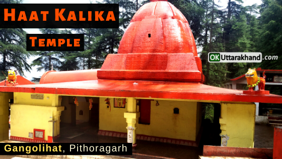
Haat Kalika Temple, Gangolihat: This temple is a major cultural center in the hills and known for its socio-religious activities. Gangolihat is situated in the midst of Saryu and Ramganga rivers. This is a place mentioned in the ancient literature of Hinduism. A famous Mahakali Shaktipeeth, Haat Kalika Temple established by Shankaracharya in the 8th century. Goddess Kali-Maa is the deity of the Indian Army’s Kumaon Regiment. Goddess Kali is the reigning deity of the Gangolihat. Pithoragarh To Gangolihat distance is 77 kilometers.
Askot Musk Deer Sanctuary: Askot Musk Deer Sanctuary is a wildlife sanctuary famous for the conservation of musk deer. It spread over 599.9 km of an area located around Askot near Didihat, in Pithoragarh district of Kumaon division in Uttarakhand. Askot is an ancient kingdom of the Katyuri dynasty of Kumaon Kingdom. The name Askot is derived from Asi-Kot, which literally means 80 forts. Askot is surrounded by tall trees and waterfalls. Pithoragarh to Askot distance is 52 km.
Kapileshwar Mahadev Temple: It is a cave temple dedicated to Lord Shiva, this unique Hindu temple is located deep inside a dark cave. Temple is situated on the outskirts of the Pithoragarh town. Tourists can have a panoramic view of the Sor Valley and the surrounding Himalayan peaks from here. Kapileshwar Mahadev is 3 km away from Pithoragarh.
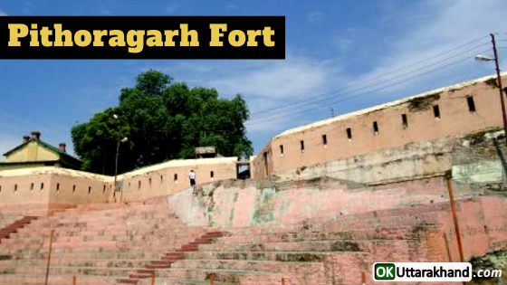
Pithoragarh Fort: Pithoragarh Fort or Gorkha Kila is set atop a hill and was built by the Gorkhas in 1789. The Government Guest House is housed in this Fort. The fort has served as a tehsil headquarters in past but now it has been completely renovated and is used as a museum by Uttarakhand Tourism Department.
Dhwaj Temple: This temple is dedicated to Lord Shiva and Goddess Jayanti or Durga. There is a mountain called Dhwaj. It is located at an altitude of 2,100 meters which offers a scenic view of the valley and the snow-capped peaks. According to Hindu legends, It is believed that at this place ‘Chanda and Munda’ demons were killed by Devi. Pithoragarh To Dwaj Temple distance is 21 km by bus and 5 km trek near Totanaula.
Thal Kedar: Thal Kedar is an ancient Shiva Temple that is also known for its scenic splendor. During the annual fair of Maha Shivratri, a large number of devotees and pilgrims flock here. Pithoragarh To Thal Kedar distance is around 20 km. This place is of great religious importance and lakhs of devotees visit Thal-Kedar every year during Shivaratri.
Dharchula: Dharchula is a Tehsil and a Nagar panchayat in Pithoragarh district in the state of Uttarakhand. Dharchula is a valley surrounded by Himalayan mountains. An ancient trading town for the trans-Himalayan trade routes. It is covered by high mountains and is situated on the banks of the river Kali. It lies on the route to the Kailash-Mansarovar pilgrimage tour. Dharchula is virtually split between India and Nepal near the border with Tibet. Pithoragarh To Dharchula distance is around 90 km.
Didihat: Didihat has views of the Himalaya ranges, especially the Panchchuli range. There are many ancient Temples in Didihat. The Sirakot Temple of Lord Malay Nath is nearby and was built by Reka Kings. Narayan Swami Ashram at Narayan Nagar is situated 10 km away from Sirakot mandir. The Ashram was primarily made to help Kailash-Mansarovar pilgrims. Pithoragarh to Didihat distance is around 54 km.
Patal Bhuvaneshwar: Patal Bhuvneshwar is a cave temple near Gangolihat. At a distance of 14 km from Gangolihat, there is a village named Bhuvaneshwar located in Didihat tehsil. Here is a cave of Patal Bhuvaneshwar, the subterranean shrine of Lord Shiva is situated with sprawling interiors exist. Various spectacular stalactite and stalagmite figures created by Limestone rock in the cave. There is a narrow tunnel-like opening which leads to a number of caves. The cave is fully electrically illuminated by the Government of Uttarakhand. Pithoragarh To Patal Bhuvneshwar distance is around 89 km.
Jauljibi: This is a significant trading center known as Jauljibi bazaar bordering Nepal and 68 km from Pithoragarh. It is situated at the confluence of rivers Gori and Kali. It turns into a lively fairground annually. In the fair Bhotiya tribes use to sell their woolen articles and handlooms. A hanging rope bridge across the Kali River links this place to Nepal.
Rai Gufa Temple: Rai Gufa is a cave noted for its queer limestone deposits and it is one of the major attractions in Pithoragarh. Inside the cave, there is a temple dedicated to Lord Shiva Ji. This cave provides an excellent example of peculiar limestone formations. Pithoragarh To Rai Gufa Distance is 2.5 kilometers.
Munsyari: Munsyari is a small town situated in the northern part of the Pithoragarh district. It remains covered with snow throughout the year. Munsyari is located at the foot of the main Himalayan peaks and it is in the base for the track routes to Milam Glacier, Ralam Glacier, and Namik Glacier at the base of majestic Himalayan peak Trishuli (7,074 m). This place is also famous for an alpine meadow known as the Khalia Bugyal.
Madkot Hot Water Springs are supposed to cure rheumatism, arthritis, and skin ailments. It is 22 km away from Munsiari. The forest ponds of Mesar Kund and Thamri Taal, close to Munsyari are also popular tourist destinations. The valley from Munsyari to Milam village is known as Johar Valley. Pithoragarh to Munsyari distance is 124 km.
Adi-Kailash (Chhota Kailash): Adi Kailash, also known as Chhota Kailash is situated at an altitude of 6,191 meters on Indo-Tibet border in Byans valley of Dharchula tehsil. Adi Kailash Trek is a very popular Trekking route. This Trek Route goes through Mangti to Jollingkong via Chialekh (Chaetoh), Garbyang, Gunji and Kuti treks. You can also see the sacred Hindu peak named Om Parvat (6,191 m) if you goes towards Kalapani from village Gunji then further to Nabhidang.
Kailash Mansarovar Yatra: The Hindu pilgrimage tour to Kailash-Mansarovar passes through the Pithoragarh district. Pilgrims have to move on foot from Mangti Nala trek. Lake Manasarovar is the world’s highest freshwater lake located at the southern foot of Mount Kailash in Tibet. This pilgrimage place attracts religious people from India, Nepal, Tibet, and neighboring countries. Bathing in Manasarovar Lake and drinking its water is believed by Hindus to cleanse all sins.
Nakuleshwar: It is believed that Nakuleshwara Temple was built by Nakula and Sahadeva (Pandava brothers). The place is located in Pithoragarh town near Deodar village.
Jhulaghat: This small town is located on the banks of river Kali at the Indo-Nepal border. It is named after a hanging rope bridge across the Kali river. Cross-border trade with Nepal takes place through this bridge. The old name of Jhulaghat is ‘Juaghat’.
Chandak Hills: Chandak is located at an altitude of 6,000 feet (1,830 m) in Pithoragarh near Soar Vally. One can see panoramic and a breath-taking view of the Chandak Hills Soar Valley from here. According to legends, it is a place where demon ‘Chandghat’ was killed by Goddess Kali Maa or Durga. Pithoragarh To Chandak Hills distance is 7 km. The temple of Mostyamanu of Lord Shiva is a locally adored place in Chandak. Every year the popular Mostamanu fair is organized by the local people here.
Chhipla Kedar: Chhipla Kedar Temple is 34 km from Tawaghat situated 4626 meters (15,177 ft) above sea level. Chipla Kedar trek is one of the most exciting and challenging trails you can tread in Uttarakhand. Chipla Kedar, a temple dedicated to lord shiva is located at the top of the trek.
Berinag: Berinag is a small town at an altitude of 2,010 m from where Himalayan snow-clad peaks can be viewed. The area has a number of Nag “Snake” temples of Dhaurinag, Feninag, Kalinag, Bashukinag, Pinglenag, and Harinag. Other tourist spots are Tripura Devi Temple, Cave Temple Koteshwar, Garaun waterfalls, and Musk Deer Farm at Kotmanya. The Berinag is named after the Nagveni King Benimadhava or Benimadhab. Pithoragarh To Berinag distance is 102 km.
Jhaltola: Jhaltola is a small village between Chaukori and Patal Bhuvanshwar. It was an erstwhile tea estate and is at an altitude of 2,100 – 2,600 meters ASL. There is an old Lord Shiva temple at the top of the mountain known as Lamkeshwar Mahadev. It is an upcoming offbeat destination for tourists interested in nature, Himalayan views and birding. Jhaltola village is surrounded on three sides by fabulous mixed forests and has the widest range of Himalayan views in Kumaon.
Thal: Thal is surrounded by Kalinag, Sundarinag, and Dhaulinag. It is situated on the bank of the Ramganga river. Thal Valley has its own history main attractions are the ancient temple of Lord Shiva and Ek Hathia Devalaya which means “Made with one hand”. This temple is dedicated to Lord Shiva. It is believed that the temple was carved by one stone and by one person in a single night. Gaucher is a nice place that is 2 miles (3.2 km) away from the Thal market in the route of Munsyari and Kailash Manas Sarovar.
Weather in Pithoragarh
Pithoragarh district has extreme variation in climate and temperature due to the large variations in altitude. The temperature rises from mid-March through mid-June. The areas above 3,500 meters (11,500 ft) remain in a permanent snow cover. Regions lying at 3,000–3,500 meters (9,800–11,500 ft) become snowbound for four to six months. At places like the river gorges at Dharchula, Jhulaghat, Ghat, and Sera, temperatures reach 35 °C.
Summer: 14°C to 29°C
Winter: 0°C to 24°C
The annual average rainfall in lower reaches is 360 centimeters (140 in). After June the district receives monsoon showers.
Pithoragarh town is relatively warm during summer and cool during winter. During the coldest months of December and January, the tropical and temperate mountain ridges and high locations receive snowfall and have an average temperature of 5°C to 8°C. Winter is a time for transhumance, the seasonal migration of the Bhotiya tribe with their herds of livestock to lower, warmer areas.
Best Time To Visit Pithoragarh
The best time to visit Pithoragarh is from March to June. Summer season is the peak time to travel Pithoragarh. Summers are quite pleasant with moderate climate while winters are chilly. However, if you like snowfall then you should visit Munsyari during the winter season.
If your like to do trekking then Pithoragarh has dozen of adventurous treks. You can visit Pithoragarh at any time of the year excluding the monsoon season (July-August).
How To Reach Pithoragarh
Pithoragarh district is not connected by any direct train services. However it is well connected by road, and it also has an airport. The National Highway 9 passes through the district. Pithoragarh is a disaster-prone district which leads to Landslides and cloudbursts. It caused by heavy rains that fall during the summer monsoon often interrupt transportation networks.
The Pithoragarh Airport is also known as the Naini Saini Airport. It is located about 5 kilometers (3.1 mi) north-east of the city. This airport was constructed in 1991 for administrative use and was previously mainly used by the Indian Air Force for defense purposes. Naini Saini Airport was upgraded in 2016 at an estimated cost of Rs 64.91 crore.
How To Reach Pithoragarh by Air
Naini Saini Airport is the only Airport in Pithoragarh district but it is not fully operational. So the nearest airport with daily flights To Dehradun is Pantnagar Airport. The Pantnagar airport is located in the Udham Singh Nagar district of Uttarakhand state. Pantnagar To Pithoragarh distance is almost 241 km. You can easily get private taxis and buses to reach any destination in Pithoragarh.
How To Reach Pithoragarh by Train
The nearest railhead to the Pithoragarh district is located in Tanakpur. Tanakpur Railway station to Pithoragarh distance is almost 147 kilometers. Other than this, Pithoragarh to Kathgodam railway station distance is 178 km. Travelers can easily get buses and taxis to reach any destination from outside the railway station.
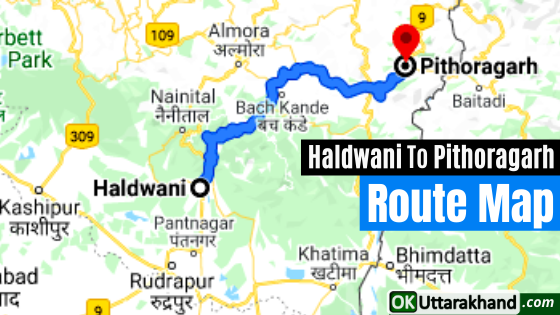
How To Reach Pithoragarh by Road
Pithoragarh district is well connected to all over Uttarakhand by all-weather motorable roads. Haldwani and Tanakpur are two entry points for entering Pithoragarh district by road. Regular Uttarakhand roadways bus services along with private taxi services are available at both places.
Buses are the most commonly used mode of transport, are run by state government agencies and private operators. Agencies operating long-distance bus services include Uttarakhand Transport Corporation (UTC), K.M.O.U, and various private operators.
Pithoragarh Distance from Major Cities
⦿ Delhi to Pithoragarh (496 km)
⦿ Dehradun to Pithoragarh (461 km)
⦿ Chandigarh to Pithoragarh (704 km)
⦿ Hyderabad to Pithoragarh (1749 km)
⦿ Bangalore to Pithoragarh (2340 km)
⦿ Ahmedabad to Pithoragarh (1408 km)
⦿ Mumbai to Pithoragarh (1712 km)
⦿ Rishikesh to Pithoragarh (427 km)
⦿ Agra to Pithoragarh (499 km)
⦿ Varanasi to Pithoragarh (752 km)
⦿ Amritsar to Pithoragarh (909 km)
⦿ Gurgaon to Pithoragarh (505 km)
⦿ Jodhpur to Pithoragarh (1063 km)
⦿ Shimla to Pithoragarh (803 km)
⦿ Jaipur to Pithoragarh (736 km)
⦿ Manali to Pithoragarh (999 km)
⦿ Kolkata to Pithoragarh (1423 km)
⦿ Chennai to Pithoragarh (2372 km)
⦿ Udaipur to Pithoragarh (1125 km)
⦿ Haridwar to Pithoragarh (408 km)
⦿ Pune to Pithoragarh (1753 km)
Important Links:
Official Website of Pithoragarh District: https://pithoragarh.nic.in
Seemant Institute of Technology, Pithoragarh: https://sitp.ac.in
LSM Government PG College Pithoragarh: www.lsmgpgcollege.org
Pithoragarh Institute Of Technology And Management: www.pitm.co.in


[…] On 15 Dec 1997, the Government of Uttar Pradesh declared Champawat as a separate district. which was carved out from the Pithoragarh district. […]