

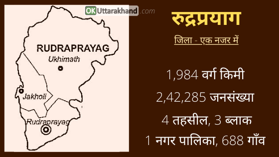
Rudraprayag is a district of the state of Uttarakhand which lies at the confluence of two rivers Alaknanda and Mandakini. Rudraprayag is one of the Panch Prayag which means five confluences of Alaknanda River. Rudraprayag district occupies an area of 1984 sq km. The town of Rudraprayag is the administrative headquarters of the district.
Rudraprayag is blessed with nature’s bounty and pilgrimage sites like Kedarnath, Tungnath and other Panch Kedar temples. Hills Stations like Chopta is one the most popular attraction for travelers and Snowfall lovers. The route of Char Dham temples like Badrinath and Kedarnath goes through places like Guptkashi, Sonprayag, and Gaurikund. These all places are located under Rudraprayag district.
Here we collected details of Rudraprayag tourism, weather, education, distance, route map and places to visit in Rudraprayag. This article will help you as a Travel Guide in Rudraprayag district.
Rudraprayag at a Glance
| Headquarter | Rudraprayag |
| Popular Places | Kedarnath, Tungnath |
| District Magistrate | Mangesh Ghildiyal |
| Area | 1984 sq km |
| Tehsils | 4 |
| Vilages | 688 |
| Population (2011) | 2,42,285 |
| Vehicle Registration | UK-13 |
| STD Code | 01364 |
| Pin Code | 246171 |
| Official Website | http://rudraprayag.nic.in |
History of Rudraprayag District
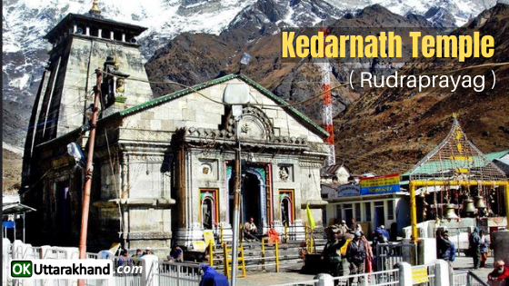
Rudra is another name of lord shiva that is why Rudraprayag is named after Lord Shiva. Rudraprayag was the part of Kedar Khand in ancient times. The Kedarnath Temple is a Hindu temple dedicated to Lord Shiva built by Pandavas and revived by Adi Sankaracharya is in Rudraprayag.
Kedarnath is one of the twelve Jyotirlingas, the holiest Hindu shrines of Shiva. Pandavas were supposed to have pleased Shiva by doing penance in Kedarnath.
Formation of Rudraprayag District
On 16th September 1997, Rudraprayag declared as a whole new district. Rudraprayag district was carved out from the areas of three adjoining districts of Chamoli, Tehri, and Pauri Garhwal.
- From Chamoli District, the whole Augustmuni & Ukhimath block and part of Pokhri & Karnprayag block merged into Rudraprayag district.
- Part of Jakholi and Kirtinagar block from Tehri Garhwal District.
- And the Khirsu block from the Pauri Garhwal District also added to the Rudraprayag at that time.
Rudraprayag Population & Demographics
According to the Census 2011,
- Rudraprayag district has a population of 242,285.
- Rudraprayag has a gender ratio of 1120 females for every 1000 males, making it the 6th highest in the country.
- The literacy rate is 82.09% in Rudraprayag district.
Culture & Languages in Rudraprayag
Living in the mountains mostly in places that are not easily accessible is very difficult, however, the people of the Rudraprayag district have been able to preserve their culture, folklore, folk songs, and folk dances. There are a number of fairs like Hariyali Devi Mela, Madhameshwar Mela, and Pandava Dance celebrated every year in Rudraprayag.
According to the 2011 Census, The predominant first language of the district is Garhwali, spoken by 94.5% of the population. Hindi, though widely used a lingua franca, is of 4.2%, while 0.60% are speakers of Nepali.
- Garhwali (94.5 %)
- Hindi (4.2 %)
- Nepali (0.60 %)
- Other (1.3 %)
Religion in Rudraprayag
Hindus are in majority in the Rudraprayag district. They are around 99.13 percent of the total population.
- Hindu (99.13 %)
- Muslim (0.61 %)
- Other (0.26 %)
Administration (Rudraprayag District)
Rudraprayag district is a district of Uttarakhand state of northern India. The district occupies an area of 1984 square kilometers. Rudraprayag town is the headquarters of the district.
- The district is bounded by Uttarkashi District on the north.
- Chamoli District on the east.
- Pauri Garhwal District on the south.
- and Tehri Garhwal District on the west.
Tehsils in Rudraprayag
There are 4 tehsils, 3 sub-divisions, 3 blocks, 688 villages, and 1 Municipality in the Rudraprayag district. Here is the list of Rudraprayag district’s tehsils, blocks, Assembly Constituency with their names.
- Rudraprayag district is divided into 4 Tehsils.
- There are 3 Sub-division and 3 Blocks in Rudraprayag district.
- There are 2 State Assembly Constituencies in Rudraprayag district.
- There are 5 Police stations in Rudraprayag district.
| Tehsil | 4 | Rudraprayag, Jakholi, Ukhimath, Basukedar |
| Sub Divisions | 3 | Rudraprayag, Jakholi, Ukhimath |
| Block | 3 | Agustyamuni, Jakholi, Ukhimath |
| Assembly Constituency | 2 | Kedarnath(7), Rudraprayag(8) |
Education in Rudraprayag
Rudraprayag is a hilly district and there are few degree colleges in the district. That is why most of the students after 12th, go to cities like Dehradun and Haridwar for their higher education. Some of the colleges and institutions in Rudraprayag are listed below.
- District Institute of Education and Training (DIET)
- Govt. Degree College Rudraprayag
- Anusuya Prasad Bahuguna Govt. P.G College
- Govt. Degree College, Jakholi
- Jawahar Navodaya Vidyalaya, Guptkashi
- Kendriya Vidyalaya Augustyamuni, Rudraprayag
Tourism in Rudraprayag
Rudraprayag is blessed with immense natural beauty, places of religious importance, lakes, and glaciers. Rudra Prayag is a small town that is located in the state of Uttarakhand and in the district of Rudraprayag. The presence of two separate routes for Badrinath and Kedarnath Dham from Rudraprayag render great importance to the place. It is situated at the confluence of the River Alaknanda and River Mandakini. It has a special religious significance for many people as well. Lakhs of visitors travel to the place to witness this phenomenon every year. The entire area is surrounded by immense beauty and one can see many lakes, glaciers, rivers, and streams here. There are a few temples that are located in the town as well and these are a must-visit while traveling to Rudra Prayag.
Places To Visit in Rudraprayag
There are a number of places of interest, temples and tourist sites in the Rudraprayag district.
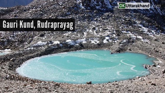
Gaurikund: Gauri Kund is a beautiful town known for its various small lakes and ponds in Rudraprayag. Gaurikund is connected with Shiva’s wife Goddess Parvati, also known as Gauri. In Hindu folklore, Gauri committed to penance involving many ascetic and yogic practices to win over Lord Shiva’s affections.
Local tradition claims that Gauri Kund is the spot where Goddess Parvati lived while carrying out these practices and it was here that Shiva finally admitted His love for Her. They were married at Triyuginarayan, which is located nearby. There are hot various springs in Gaurikund and they are converted to bathing places.
Kedarnath Temple: Kedarnath Dham has located at the Garhwal Himalayan range near the Mandakini river in Kedarnath town, Uttarakhand in India. Due to extreme weather conditions, the temple is open only between the end of April (Akshaya Tritiya) to November (Kartik Purnima – the autumn full moon). During the winters, the deities from Kedarnath temple are brought to Ukhimath and worshipped there for six months.
Chopta Valley: Chopta is a small settlement and valley that is located in Uttarakhand. It is very popular among tourists, mainly because of the number of options it provides for exploring, adventure buffs and trekking enthusiasts. Chopta is also a base for trekking to Tungnath, third temple of Panch Kedar, which lies 3.5 kilometers uphill.
Tungeshwar: This temple is located in the near Chopta and has been here for centuries. Folklore has it that the Pandavas came here for penance. On the way from Chopta, there were many small temples up to the Tunganath Temple, the remains of some are still there. On the temple wall, there are terracotta style seals and Shiva-Parvati figurines.
Chandrashila Trek: Chandrashila is a famous trekking destination for adventure travelers. The Chopta valley has many treks and trails cutting through jungles and grasslands. Chandrashilla, Tunganath, and Devariyatal are the best-known trekking routes in the Chopta. Because of an abundance of birds, treks are becoming popular among birdwatchers.
Ukhimath: Omkareshwar Temple of Ukhimath is situated at an elevation of 1311 meters. This is the winter seat of Lord Kedarnath and worship is done here during the winters when the temples of Kedarnath remain closed for six months. The temples of Usha and Aniruddha, Lord Shiva and Parvati are worth visiting here. Rudraprayag To Ukimath distance is 41 km. and Rudraprayag To Guptkashi distance is 13 km. Some other famous nearby temples are Madmaheshwar and Triyuginarayan.
There are several other adventure treks, and lakes like Vasuki Tal, Deoria Tal, Badhani Tal are located in and around the district.
Weather in Rudraprayag
Rudraprayag weather varies from normal to extreme cold. The climate depends upon the height of the region. Some places like Kedarnath remain close for six months due to minus degree temperatures. Rudraprayag has a pleasant climate in the summer season.
Min Temp: 5 °C
Max Temp: 26 °C
The maximum temperature in Rudraprayag town rises up to 26°C and the minimum temperature falls to about 5°C. The best time to visit Rudraprayag is in the month of June during Char Dham Yatra.
How To Reach Rudraprayag
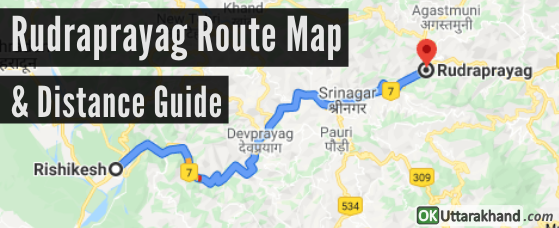
Rudraprayag is situated at the holy confluence of Alaknanda and Mandakini rivers, at a distance of 34 km from Srinagar (Garhwal).
How To Reach Rudraprayag By Air
The nearest airport for Rudraprayag district is Jolly Grant Airport Dehradun which is around 160 kilometers. (Dehradun To Rudraprayag distance is 160 kilometers)
How To Reach Rudraprayag By Train
The nearest railhead for Rudraprayag is Rishikesh Railway Station which is at a distance of 141 km. Rishikesh is well connected to major cities of the northern railway.
How To Reach Rudraprayag By Road
Rudraprayag lies on national highway NH58. It connects Delhi with Badrinath and Mana Pass in Uttarakhand near the Indo-Tibetan border. Therefore, all the buses and vehicles that carry pilgrims from New Delhi to Badrinath via Haridwar and Rishikesh in the pilgrim season of summer months. This route pass-through Rudraprayag on the way to Joshimath and further north.
Rudraprayag is well connected to all districts of Uttarakhand by road. Rishikesh is a starting point for road journeys to Rudraprayag district and regular roadways and private buses operate from Rishikesh bus station to Rudraprayag. Rishikesh to Rudraprayag distance is around 141 km (88 mi) via Devprayag and Srinagar. Rishikesh(140 Km), Haridwar(160 Kms), Tehri(112 Kms), Pauri Garhwal(62 Kms) and Nainital(273 Kms).
Rudraprayag Distance from Major Cities
⦿ Delhi to Rudraprayag (410 km)
⦿ Dehradun to Rudraprayag (180 km)
⦿ Chandigarh to Rudraprayag (352 km)
⦿ Hyderabad to Rudraprayag (1904 km)
⦿ Bangalore to Rudraprayag (2495 km)
⦿ Ahmedabad to Rudraprayag (1345 km)
⦿ Mumbai to Rudraprayag (1821 km)
⦿ Rishikesh to Rudraprayag (141 km)
⦿ Agra to Rudraprayag (551 km)
⦿ Varanasi to Rudraprayag (946 km)
⦿ Amritsar to Rudraprayag (568 km)
⦿ Gurgaon to Rudraprayag (401 km)
⦿ Jodhpur to Rudraprayag (1000 km)
⦿ Shimla to Rudraprayag (407 km)
⦿ Jaipur to Rudraprayag (672 km)
⦿ Manali to Rudraprayag (632 km)
⦿ Kolkata to Rudraprayag (1617 km)
⦿ Chennai to Rudraprayag (2528 km)
⦿ Udaipur to Rudraprayag (1161 km)
⦿ Haridwar to Rudraprayag (161 km)
⦿ Pune to Rudraprayag (1816 km)
Important Links:
Official Website of Rudraprayag District: https://rudraprayag.gov.in
District Institute of Education and Training (DIET): http://www.dietrudraprayag.ac.in
Govt. Degree College Rudraprayag: http://www.gdcrpg.in/home.php
Anusuya Prasad Bahuguna Govt. P.G College: http://www.gpgcagastyamuni.org


[…] District: Rudraprayag […]
[…] to Haridwar or Rishikesh to Devprayag to Srinagar to Rudraprayag to Tilwara to Agastamuni to […]
[…] जिला: रुद्रप्रयाग […]
[…] Destination – Kedarnath Temple in Rudraprayag District. (Deity: Lord […]