

Tehri Garhwal is one of the largest districts in the hill state of Uttarakhand, India. Its administrative headquarters is at New Tehri which is a beautiful town and emerging hill station destination among tourists. The district of Tehri Garhwal is one of the largest districts in Uttarakhand. This district is considered to be one of the holiest places in the state.
It is located in the foothills of the Himalayas and is a part of the southern slopes of mid-Himalayas. There are many places that you can visit during your trip to Tehri Garhwal, as there are numerous temples, forts, and lakes in the region.
This article will help you as a travel guide in Tehri Garhwal district. Here we compiled the detailed guide on Tehri Garhwal tourism, weather, education, distance, route map and places to visit in Tehri.
Tehri Garhwal at a Glance
| Headquarter | New Tehri |
| Popular Places | Srinagar, Devprayag, New Tehri |
| District Magistrate | Dr. V. Shanmugam (IAS) |
| District Court | New Tehri |
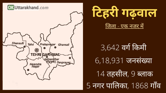
| Area | 3642 Sq. Km. |
| Tehsils | 14 |
| Vilages | 1868 |
| Population (2011) | 6,18,931 |
| Vehicle Registration | UK-09 |
| STD Code | 01376 |
| Pin Code | 249001 |
| Official Website | https://tehri.nic.in |
History of Tehri Garhwal
Tehri and Garhwal are the two words and regions combined for naming the district as Tehri Garhwal. While the prefix “Tehri” is the corrupted form of the word “Trihari” which signifies a place that washes away all the three types of sins, namely sins born out of thought (Mansa or Vichar), word (Vacha or Vachan) and deed (Karmana or Karm), the other part Garh means country fort.
Ancient Period: It is believed that Before the creation of the universe, Lord Brahma has meditated on this sacred land. Muni-ki-Reti and Tapovan are the places of penance for the ancient Rishis. Its hilly terrain and lack of easy communications have helped it to preserve its cultural heritage almost intact. Traditionally the region finds mention in various Hindu scriptures as Kedar Khand being home to the Garhwali people.
List of Garhwal Kingdom Dynasty
- Katyuri dynasty (6th-11th centuries)
- Parmar dynasty (12th-15th centuries)
- Shah dynasty (18th centuries)
- Shah dynasty with Princely state (1815–1949)
101 AD – 6th Century: The Garhwal Kingdom was always dominated by Kshatriyas. The Kuninda Kingdom also flourished around the 2nd century in the present-day region of Uttarakhand and Himachal. Later this region came under the rule of Katyuri Kings, who ruled unified Kumaon and Garhwal regions from Katyur Valley in Bageshwar district.
Katyuri dynasty started in the 6th century AD and eventually faded by the 11th century AD. They were replaced by Chand Kings in Kumaon while Garhwal was fragmented into several small principalities.
In fact, during olden days possession of the number of forts was considered as a significant measuring rod of the prosperity and power of their rulers and kings. Prior to 888 AD, the whole of the Garhwal region was divided into small 52 Garhs (forts) ruled by separate independent kings known as Rana, Rai or Thakur.
823 to 18th century: The royal dynasty of Garhwal started with Kanakpal. Garhwal Kingdom was founded in 823 AD. It is said that the prince of malwa king Kanakpal visited Badrinath Ji (presently in Chamoli district) where he met the then mightiest king Bhanu Pratap. King Bhanu Pratap was impressed with the Kanakpal and got his only daughter married to him and also handed over his kingdom. Gradually Kanakpal and his descendants extended their empire by conquering all the Garhs in the region. After this, They ruled for another 915 years and the whole of the Garhwal region remained under their control until 1803.
1794 to 1883: During 1794-95, Garhwal was under the grip of severe famine and again in 1883, the Garhwal was terribly shaken by an earthquake. Gorkha rulers had by then started invading this territory and heralded their influence over the region. The people of the Garhwal region already affected by natural calamities were in the deplorable condition and therefore could not resist the Gorkhas invasion. On the other hand, Gorkhas whose several attempts for capturing the fort Langoor Garhi had earlier failed, were now in a powerful position in 1803.
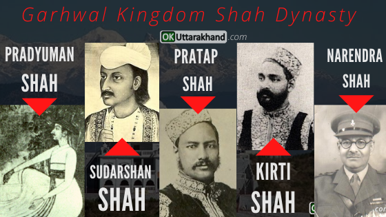
After 1883: Gorkhas again invaded the Garhwal region and Pradyumna Shah was the ruler at that time. King Pradyumna Shah was killed in the battle in Dehradun but his only son (Sudarshan Shah was minor at that time) was cleverly saved by the trusted courtiers. With the victory of Gorkhas in this battle, their dominion was established in the Garhwal region. Later on, their kingdom extended up to Kangra. They managed to defeat King Sansar Chand Katoch, the ruler of Kangra in 1806 with the help of many provincial chiefs. However, Gorkhas could not capture the Kangra fort which came under Maharaja Ranjit Singh in 1809. They ruled over this Kangra region continuously for 12 years before they were thrown away by Maharaja Ranjit Singh.
1814-1816 (Battle of Nalapani): During this time, Sudarshan Shah already struggling from other rulers from Nepal. Thus he could manage help from the East India Company and got his kingdom freed from other Gorkha rulers from Nepal. The East India Company merged Kumaon, Dehradun and east Garhwal in the British Empire and the west Garhwal was given to Sudarshan Shah which was then known as Tehri Riyasat.
1815-1949: Shah dynasty ruled over this region from 1815 to 1949. King Sudarshan Shah established his capital at Tehri town (Old Tehri) and afterward his successors Pratap Shah, Kirti Shah, and Narendra Shah established their capital at Pratap Nagar, Kirti Nagar, and Narendra Nagar respectively.
Formation of Tehri Garhwal District
In 1942, during the Quit India Movement people of Tehri Riyasat actively participated in the independence of the country India. Ultimately when the country was declared independent in 1947, the inhabitants of Tehri Riyasat started their movement for getting themselves freed from the clutches of Maharaja rule.
Due to the movement, the situation became out of his control and it was difficult for him to rule over the Tehri Garhwal region. Consequently, the 60th and the last ruled king of Pawar Vansh Manvendra or Manbendra Shah accepted the sovereignty of the Indian Government.
- In 1949, Tehri Riyasat ended and was merged in Uttar Pradesh as a new district. But Being a scattered region, it posed numerous problems for expediting development. Resultantly,
- On 24th February 1960, the U.P. Government separated Uttarkashi tehsil from Tehri district and given the status of a separate district named Uttarkashi.
- In the 1960s, Tehri Garhwal extended much farther east than it currently does.
- In 1997, much of the eastern portion of Tehri Garhwal was detached and merged with portions of the Pauri Garhwal district and the Chamoli district to form the Rudraprayag district.
- On 9 November 2000, the Tehri Garhwal district became part of the newly formed Uttaranchal, the 27th state in the Republic of India.
Tehri Garhwal Population & Demographics
According to the Census 2011,
- Tehri Garhwal district population is around 6,18,931 (6 Lakhs).
- Tehri Garhwal has a gender ratio of 1078 females for every 1000 males
- There is a literacy rate of 75.1% in the district of Tehri Garhwal.
Culture & Languages
Tehri and Garhwal are the two words combined for naming the district as Tehri Garhwal. It is a hilly terrain district of Uttarakhand. From the ancient period, Tehri Garhwal being home to the Garhwali people and lack of easy communications have helped it to preserve its culture almost intact.
The major first language of the district is Garhwali, accounting for 90% of the population according to the 2011 census. Hindi is widely used as a lingua franca but has 6% as the first language of the people. Other languages spoken include Jaunsari is 1% and Nepali is 0.95 percent.
- Garhwali (90 %)
- Hindi (6 %)
- Jaunsari (1 %)
- Nepali (0.95 %)
- Other (2.05 %)
Religion in Tehri Garhwal
Hindus are in majority in the Tehri Garhwal district. They are around 98.53 percent of the total population.
Hindu (98.53 %)
Muslim (1.19 %)
Other (0.28 %)
Administration (Tehri Garhwal District)
Tehri Garhwal district is in the Garhwal division of Uttarakhand. It stretches from the snow-clad Himalayan peaks of Thalay Sagar, Neelkanthand and the Gangotri group all the way to the foothills near Rishikesh.
The gushing river Bhagirathi which runs through the center seems to divide the district into two. While the Bhilangna, Alaknanda, Ganga, and Yamuna rivers border it on the east and west.
- Tehri Garhwal is surrounded by Uttarkashi district in the north,
- Pauri Garhwal district in the south,
- Rudraprayag district in the east, and Dehradun district in the west.
The district of Tehri Garhwal is divided into 5 subdivisions. It has 12 tehsils, 2 sub-tehsil, 9 blocks, and 5 municipalities. The district covers 1038 gram panchayats and 1,868 revenue villages.
Tehsils in Tehri Garhwal
Tehri Garhwal district is subdivided into 14 tehsils including 2 sub-tehsil.
Balganga, Devprayag, Dhanaulti, Gaja, Ghansali, Jakhanidhar, Kandisaur, Kirtinagar, Madannegi, Nainbagh, Narendranagar, Pavki Devi, Pratapnagar, Tehri
Blocks in Tehri Garhwal
Tehri Garhwal district is further divided into 9 development blocks.
- Fakot (Narendranagar)
- Chamba
- Jaunpur
- Thauldhar
- Pratapnagar
- Jakhanidhar
- Hindolakhal
- Kirtinagar
- Bhilangna
Constituencies in Tehri Garhwal
There are 6 Assembly Constituencies in the Tehri Garhwal district.
- Ghansali(09)
- Devprayag(10)
- Narendranagar(11)
- Pratapnagar(12)
- Tehri(13)
- Dhanaulti(14)
Education in Tehri Garhwal
Being a hilly district of Uttarakhand, Tehri Garhwal has few degree colleges but has Campus of India’s first Hydro Engineering College. THDC Institute Of Hydropower Engineering Technology is a college located in Bhagrathipuram Tehri town in the Tehri Garhwal district of Uttarakhand state in northern India. Some of the other degree colleges in Tehri Garhwal are listed below.
- Government Polytechnic, Tehri Garhwal
- SP Memorial College of Advance Studies, Garhwal
- DAAS college of Management and Technology, Tehri Garhwal
- Bal Ganga Mahavidyalaya, Sendul
- Rajkiya Snatak Mahavidhyalay, Lambgaon
- Government Degree College, Nainbagh
- Balganga Degree College, Silyara
- Uttarakhand University of Horticulture & Forestry (UUHF), Ranichauri
- Swami Purnanand Degree College of Technology, Tehri Garhwal
- Rajkiya Mahavidyalaya, Paukhal
- Government PG College, New Tehri
- Govt Degree College, Chandrabadani
- Government Polytechnic, Narendranagar
- Sri Dev Suman Uttarakhand University, Badshahithaul, Chamba
- HNB Garhwal University, SRT Campus, Badshahithaul, Chamba
- State Institute of Hotel Management, Near M & L Block, New Tehri
Tourism in Tehri-Garhwal
Tehri Garhwal is a beautiful place in Uttarakhand state which has emerged as a popular destination among tourists in the last few years. The old town of Tehri sat at the meeting of two rivers; the Bhagirathi and Bhilangna. Tehri is an ancient place and it is one of the most sacred places in India. The diverse nature of the Hindu religion has attracted lakhs of foreign visitors here from all around the world.
Places To Visit in Tehri

There are a number of places of interest and tourist sites in the Tehri Garhwal district.
Tehri Dam: Tehri Dam is the most important thing to see in Tehri Gharwal. Tehri Dam is the main Attraction of Tehri Gharwal. The Tehri Dam is the highest dam in India and one of the highest in the world. It is a multi-purpose rock and earth-fill dam built on the Bhagirathi waterway close to Tehri in Uttarakhand. It is maintained by THDC India Ltd.
New Tehri: The adventure activities at New Tehri town can attract anyone. The hilly town includes many tourism aspects like the Tehri Lake Festival, Jet Ski, Bhagirathipuram and Badshahithaul. Water Sports activities at Tehri lake is also very popular among youngsters. There are two new markets as well which were developed after the new town, the Baurari market and Kulna market.
Temples: Famous holy temples Kunjapuri, Buda Kedar, Sem Mukhem Surkanda Devi, Chandrabadni Shakti Peeth and many more also attract tourists from all over India.
Trekking: Many treks like Khatling Glacier, Panwali Kantha Trek, Masar Tal-Vasuki Tal Trek and many more are there in the district.
Devprayag & Chamba: Devprayag is one of the five scared Prayags “Panch Prayag” (confluences) of the Alaknanda, and Chamba is a township lying high at an altitude of 1524 Mts., offering a splendid view of the snow-capped Himalayas and the serene Bhagirathi valley, Similarly, Chandrabadni mountain hold a beautiful temple which commands a beautiful view of the Surkunda, Kedarnath, and Badrinath peaks.
Hill Stations: There are several Hill stations like Dhanolti, Srinagar, Chamba, and New Tehri are there that are popular among snowfall lovers. Other Places to visit in the districts are Kanatal, Devprayag, Kempty Fall, Narendranagar, etc.
As we said earlier, Tehri Garhwal has huge potential to become one of the top tourist attractions of India. The Tehri lake here provides a hundred opportunities to the adventure lovers who love to throw caution to the winds. Be it Scuba Diving, Angling, Canoeing, Rowing, Boating, Water scooter, speed Boating, Rafting, Kayaking, House Boat, Camping, Cruise boating. Or any other water sports that you can think is there and many more to come. The government is planning to make Tehri Lake as the biggest water sports center.
Weather in Tehri Garhwal
The Temperature in Tehri Garhwal differs from the height of the region. Places like New Tehri lies on 1799m above sea level, and the climate is warm and temperate in Summer. But in winter, there is a chance of snowfall occurs in New Tehri. The rainfall here is around 1934 mm/76.1 inches per year.
Min Temp: -2.2 °C
Max Temp: 33.2 °C
The best time to visit Tehri Garhwal is throughout the year but if you are an adventure lover than must-visit during Tehri Lake Festival.
How To Reach Tehri Garhwal
Tehri Garhwal is connected to all the districts of Uttarakhand by a motorable road. With its proximity, Tehri to Dehradun distance is 110 km and Tehri To New Delhi distance is 310 Kilometers. It is accessible to both Indian and Foreigner tourists, who can reach easily. New Tehri itself is a modern town now spread over an altitude from 1,550 to 1,950 metes above sea level, overlooking the gigantic lake and the Tehri Dam. In fact, the USP of New Tehri is this Tehri Jheel/lake and Dam.
How To Reach Tehri by Air
The nearest airport to Tehri Garhwal is Jolly Grant airport. It is located at a distance of 86 kilometers away from the area. Flights available from Delhi to Jolly Grant Dehradun airport on a regular basis. Cabs and taxis are easily available at the airport for hiring to New Tehri and neighboring areas.
How To Reach Tehri by Train
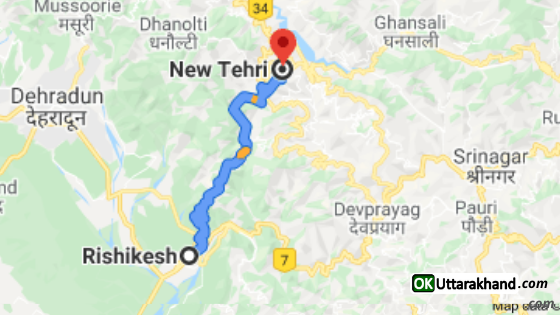
The nearest railway station to Tehri Garhwal is placed in Rishikesh. The Rishikesh railway station is at a distance of 72 kilometers from New Tehri. Motorable roads are also well joined with Tehri Garhwal. The common connecting city is Delhi for most of the trains in Rishikesh Railway Station.
How To Reach Tehri by Road
New Tehri is the headquarters of the Tehri Garhwal region so it is well connected with most of the major cities in the state like Dehradun, Rishikesh, and Haridwar. Buses and cabs are easily available from the major cities across the Garhwal region.
New Tehri Distance from Major Cities
⦿ Delhi to New Tehri (310 km)
⦿ Dehradun to New Tehri (110 km)
⦿ Chandigarh to New Tehri (269 km)
⦿ Hyderabad to New Tehri (1835 km)
⦿ Bangalore to New Tehri (2426 km)
⦿ Ahmedabad to New Tehri (1276 km)
⦿ Mumbai to New Tehri (1752 km)
⦿ Rishikesh to New Tehri (73 km)
⦿ Agra to New Tehri (482 km)
⦿ Varanasi to New Tehri (894 km)
⦿ Amritsar to New Tehri (509 km)
⦿ Gurgaon to New Tehri (332 km)
⦿ Jodhpur to New Tehri (931 km)
⦿ Shimla to New Tehri (325 km)
⦿ Jaipur to New Tehri (603 km)
⦿ Manali to New Tehri (550 km)
⦿ Kolkata to New Tehri (1564 km)
⦿ Chennai to New Tehri (2458 km)
⦿ Udaipur to New Tehri (992 km)
⦿ Haridwar to New Tehri (92 km)
⦿ Pune to New Tehri (1750 km)
Important Links Related To Tehri:
Official Website of Tehri Garhwal District: https://tehri.nic.in
THDC India Limited: https://www.thdc.co.in
Uttarakhand University of Horticulture & Forestry (UUHF), Ranichauri: https://www.uuhf.ac.in
THDC Institute of Hydropower Engineering and Technology, Tehri: http://thdcihet.ac.in
Sri Dev Suman Uttarakhand University, Badshahithaul, Chamba: https://www.sdsuv.ac.in
State Institute of Hotel Management, New Tehri: https://www.sihmtehri.org


